
By Dr. Nikos Mazarakis
Professor of Naval Meteorology

2024 was a year with strong weather fluctuations but also with the absence of very strong phenomena. It will certainly stand out as the warmest year, at least since 2017, while the summer of 2024 was the warmest ever observed. In terms of rainfall, the year up to the end of October was nightmarish since the rains that had occurred were well below average. However, thanks to the abundant rains of November and December that followed, the amount of rainfall finally reached close to average. Climate change seems to be leaving its indelible marks on the environment of our country since for the first time the holly trees in our mountains dried up. This spring, although our mountains turned green again, many of the holly trees failed to recover and so the brown color on the slopes still remains. So let's take a detailed look at the weather forecast for 2024.
Rainfall
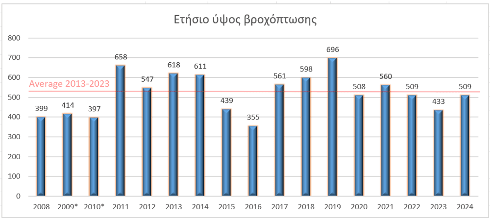
The total rainfall recorded in 2024 reached 509 mm, which corresponds to 509 tons of water per hectare. As we can see in Figure 1, the amount was slightly lower than the average for the period 2013-2023 (524.6 mm – red line in the diagram). The reason for choosing this specific period is that there are no losses in the recording of rain due to damage or clogged rain gauges. The year was generally close to the average for the Monemvasia region, but with significant, as we will see below, variation in rainfall during the year.
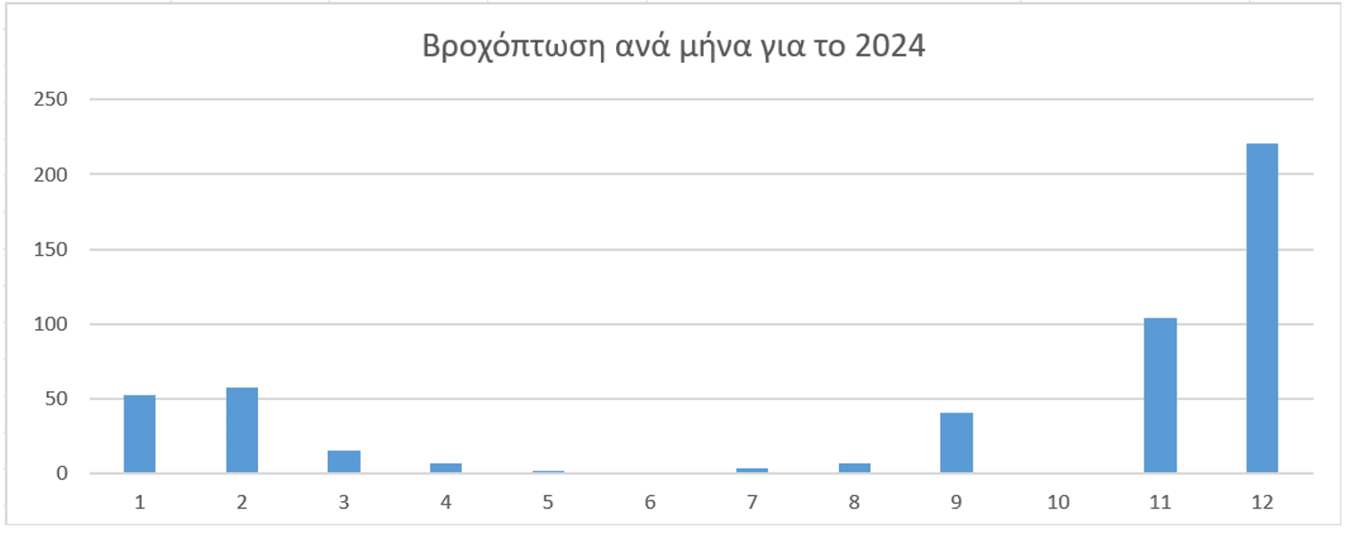
More specifically, as shown in Figure 2, the year began with generally little rain, since in January only 52.4 mm were recorded, which is 46% of the average value for the period 2013-2023 (see relevant table). In February, the rains that were recorded were slightly above average. More specifically, the rainfall reached 57.6 mm when the average value is 51.7 mm.

March with just 15.4 mm was disappointing since this amount corresponds to just 37% of the normal amount for the month which is 42 mm. Both April and May that followed with 6.6 mm and 1.4 mm respectively, were below the 50% average. So when summer came the year was already lost, since the total 9.8 mm that was recorded was extremely low, as was expected for the warm period of the year. Autumn began with optimism since the 40.8 mm of September was above the average for the month by 13 mm but the October that followed was dry, since for the first time since 2008 when we have instrumental records, the phenomenon of no rain on the 2ndThe autumn month.
By the end of October, only 184.2 mm had fallen for the entire year, and 2024 was in danger of being the driest year in at least 16 years. However, the race was decided in the delays, since in the two months of November and December that followed, something unique happened. 325.2 mm fell, which were divided into 104.2 mm in November and 221 mm in December. In fact, December was the rainiest month ever observed since 2008, since the previous record was held by January 2019, with 218.8 mm. It is also noteworthy that the monthly rainfall has only exceeded 200 mm twice, in 2019 and 2024.
Temperature
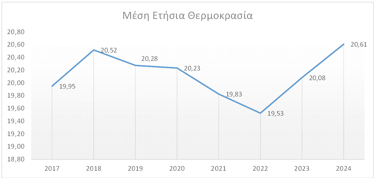
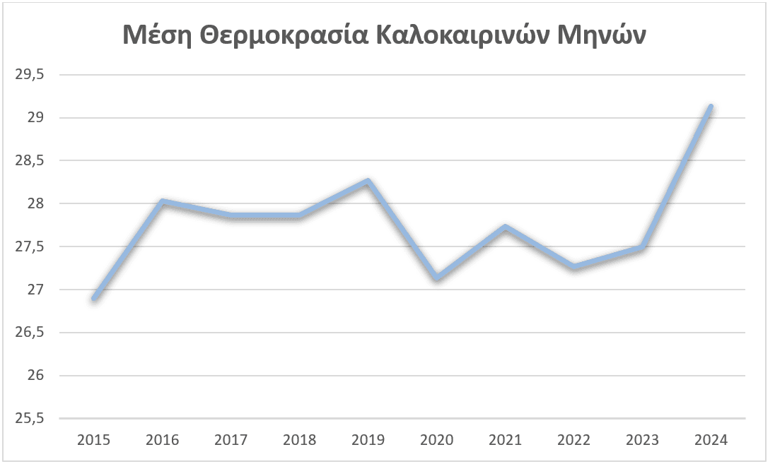
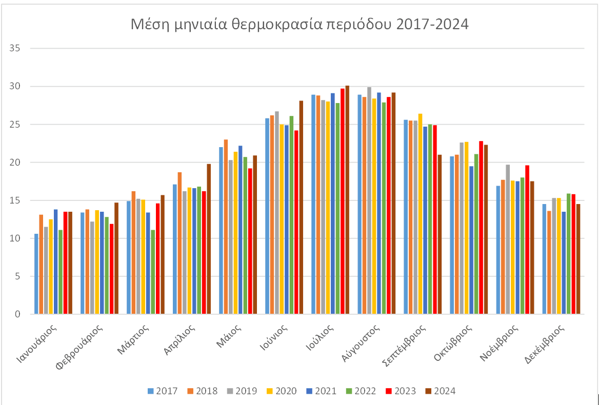
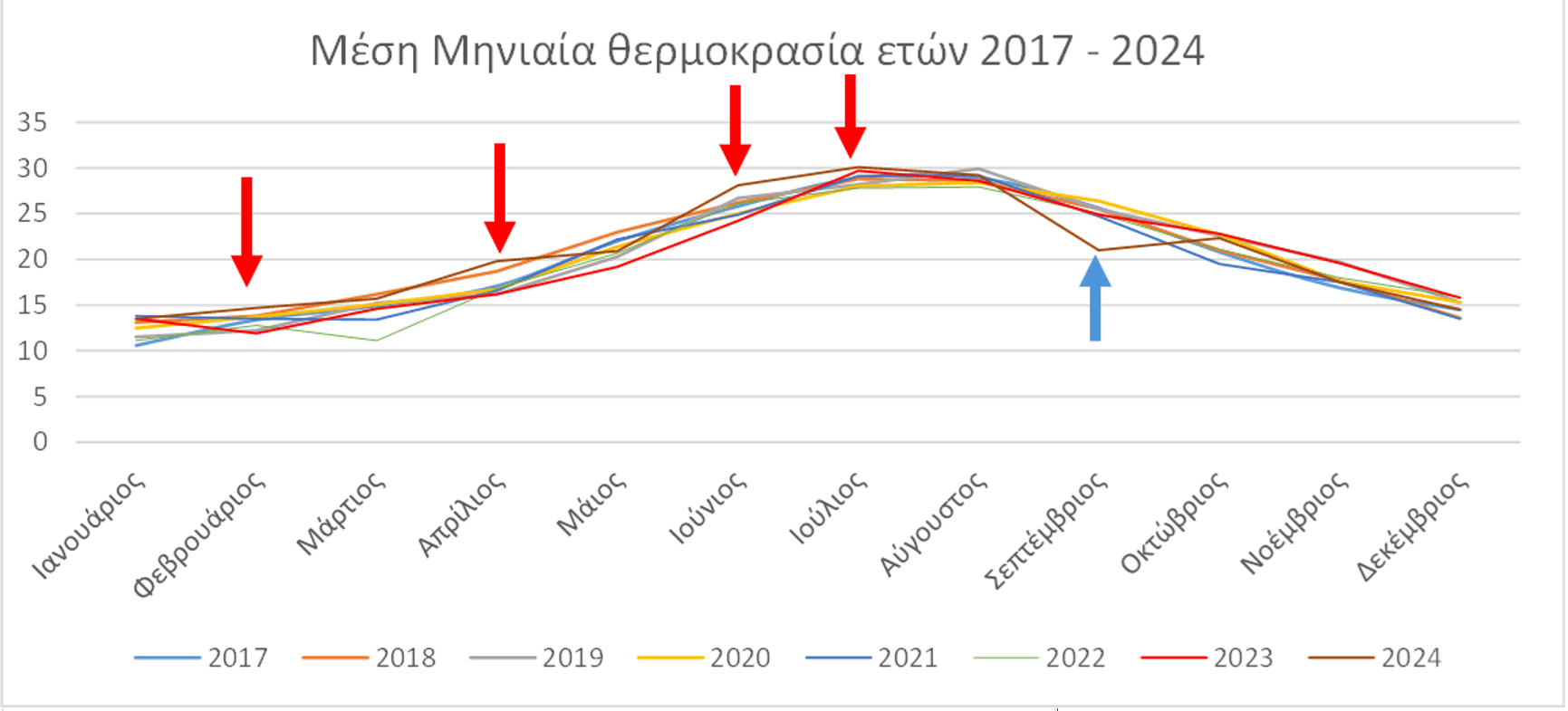
In addition to the record for the wettest month of the last 18 years, 2024 also holds another sad record. That of the warmest year since 2017 (see chart 3), with an average temperature of 20.61 degrees. We also had the warmest summer ever observed, since the average temperature was 29.1 degrees (see chart 4). It is also noteworthy that February, April, June and July were the warmest months recorded since 2017 (see chart 5). In general, almost all months were very warm, even if they did not break previous records and only September was colder than normal.
Wind
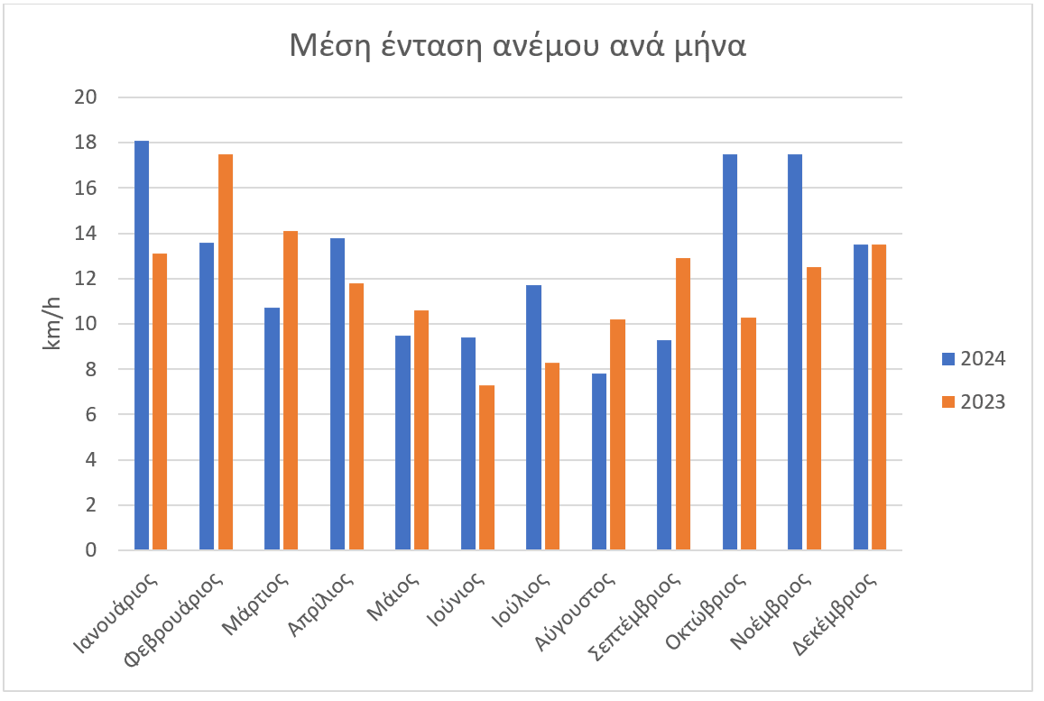
Figure 7 shows the average wind intensity by month, where we see that January had the strongest winds, followed by October and November with slightly lower intensity. The month with the mildest winds was August, which is unusual, since August is traditionally a month of meltemi. Regarding the direction, the writer of this article repaired the wind vane on May 8, so we can say that from May onwards the prevailing wind direction was north or northeast, with the exception of August when it was southeast, September west and December, south southwest, a fact that is linked to the intense activity in barometric lows, which also brought the heavy rains in that month. In general, average wind speeds were higher compared to 2023. The four highest speeds were on July 10 with 101.4 km/h, June 21, November 23 and December 26 with 90.1 km/h.
 Greek
Greek  English